Let me start by saying, this isn’t an easy hike…
There are not a lot of great descriptions out there for this hike and what we thought was a good description, turned out not to be. We probably would have been better off if we just used our instincts and followed the footprints and cairns. Ultimately, we had to turn around before we could get to the mouth of Neon Canyon as we REALLY didn’t want to be hiking through the desert and trying to routefind in the dark. It was the right decision, and it made it glaringly clear that we had not taken the right, or easy, route on the way out. We will come back next year and do this hike again–this time all the way to the Golden Cathedral.

Neon Canyon and Golden Cathedral are located in the the Grand Staircase-Escalante National Monument. To reach the trailhead, you turn off scenic byway 12 and head down Hole in the Rock road. There are a number of roads, off-shoots and trailheads along this road and to do this hike, you turn left onto the Egypt Road at 26km or 16 miles. The TH signs are pretty small so best to watch your odometer to know when to watch for the turn off. Once you turn onto Egypt Road, you will follow this for 15km (9.3miles) where you will fork right and then reach the Egypt TH parking lot at 15.9km (9.9miles).

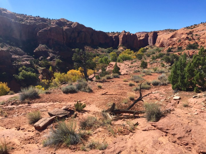
From the parking lot, it isn’t exactly clear where the trailhead is. Walk towards the canyon and look for the start of switchbacks–it might take you a minute but the trail is there. You will follow a few switchbacks and then end up on the slickrock. This is the start of where we got confused. There are cairns heading off to the left (which is not the way you want to go). You will want to head straight for the mound of slick rock (that is just to the left of my husband’s head in the photo above) and follow the cairns from there. You will know you are on the right path when you see the Glen Canyon NRA sign at the bottom, and a sandy trail that is full of boot prints. If all else fails, your final destination is the round slickrock dome in the top right corner of the photo above, although you will have to hike to the left of this to be able to drop down to the Escalante River through Fence Canyon.

We ended up bearing northeast (like the description told us to) and when we saw some cairns, we figured we were on the right track. Wrong. We ended up hiking about 1 hour out of our way before we lost all cairns and bootprints and ended up having to blaze our way through the desert to connect back with the trail.
At the end of the day, it really doesn’t matter which way you go, as long as you do connect with the trail down into Fence Canyon. It would have been nice not to have wasted about an hour meandering through the desert as it would have given us enough time to get into Neon Canyon and Golden Cathedral. It was simple enough to find our way across the desert though.
Once you hit Fence Canyon, you will enter along the left side of the canyon (or right if you are heading out of the canyon on the way back). The trail will alternate between sand and a well-trodden path as you switchback down into the canyon. Once you are closer to the bottom, you will be walking through tall reeds and may have to cross a small stream or two. You will know you are at the Escalante River when you reach it. When you get here, it’s not exactly clear where you should be crossing the river, as there seem to be several places to do so. There was an easy access route into the river but no easy way to get out of the river directly across. There was a pretty steep and sandy bank about 5-6ft high with only small reeds to grab onto on the other side. My husband decided to cross here but I found a spot further upstream that was easier to get into the river and climb the opposite bank–the river tends to be the most shallow where it is the widest. No matter where you cross, do not expect to find a defined trail. There may be what seems to be trails but because of the flooding that ravages the canyon, you will likely have to do some route finding.
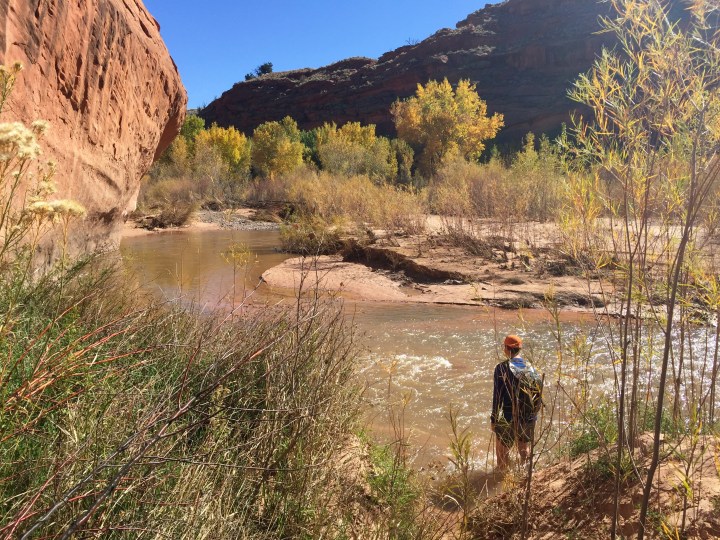
Once we were on the other side, my husband and I spent what felt like hours (it was probably about 20min) bushwhacking through reeds, willows, grass and trees until we came again to the Escalante River and our second crossing. We had read in one of the trail descriptions that you have to cross the river three times before you will reach the tributary to Neon Canyon. So onwards we pushed. By the time we came to our fifth river crossing, and a good hour of bushwhacking, we could see that we still had at least another bend or two in the river before we reached Neon Canyon. It had taken us 3 hours to get here and we made the decision to turn back assuming that if it took us 3 hours to get back we would be cutting it close to sundown.

Because there really weren’t any defined trails, we decided to head to the far side of the canyon (the left side heading downstream or the right side if you’re heading upstream). This proved to be a good decision as once we made our way through a particularly thick section of trees there was a good section to cross. From here the vegetation was not as thick and it brought us back to very close to where we entered the river in the first place. Rather than crossing and tunnelling through more reeds, we just walked up the river and were able to join up with the trail. This may not work every time as the river levels change, but if you are able to walk through the river, it is much easier to do this rather than crossing and fighting the riparian vegetation multiple times. When you are coming down through Fence Canyon, try and enter the river as far right as you can. The water is fairly deep right next to the rock but if you head towards the middle of the river, you can walk downstream to a bend in the river where it gets very shallow. This is a good spot to exit the river and overland to the next bend in the river.
If we had done this in the first place, we would have likely saved ourselves 30-40 minutes and may be been able to make it into Neon Canyon and up to Golden Cathedral. From the Escalante River up through Fence Canyon, the trail is very well defined, and as you climb out of the canyon, it became obvious that we had taken the wrong route on the outset. There is definitely a defined path through sand and slick rock. Keep following the foot prints and the cairns.
Although very challenging due to the poor directions and route finding, it was an incredible hike and allowed for great views of the area when we were hiking through the desert. Now that we know the route, we will definitely be back next year. Watch for Part 2 that will include photos and a description of Neon Canyon and the Golden Cathedral.


Looks fantastic. Shame it was a bit hamstrung by poor signage…always a frustration!
LikeLike